


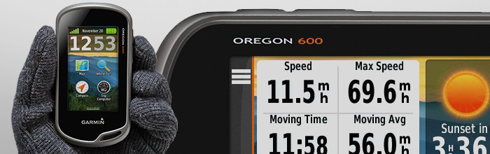
Garmin handheld Oregon 600
Maps and navigation
To add more maps to Oregon 600 you simply load TOPO U.S. 24K maps, plug in BlueChart g2 preloaded cards or use City Navigator NT map data for routing on roads. With BirdsEye Satellite Imagery you can add satellite images to your maps and display and enter grid references in IG or in the new ITM grid.
Stay connected
Sharing your photos, Garmin Adventures, custom maps, tracks, routes, and geocaches is easy with Oregon 600. You can send anything to a compatible Garmin device with just one touch.
Have fun with geocaching
With Oregon 600 handheld you are able to download up to 4 million geocaches. Paperless hunting for geocaches is even more fun with all the descriptions, hints, and logs. This GPS even arrange them by size, terrain, difficulty and type filters.
Plan your next trip
To view and organize maps, routes, and waypoints you can choose to use the BaseCamp app, which allows you to create Garmin Adventures and share them with family and friends. You can see the topographic map data in 2D or 3D on your computer screen with included contour lines and elevation profiles.
Battery life
Dual battery system requires 2 AA batteries or rechargeable internal NiMH pack. You choose how you charge your Oregon.
Warning:
In case of purchasing a device, contact us on +386 45 112 880 or +386 31 681 018 or write to us at bokal.sport@gmail.com, because the actual stock may deviate from the situation in the online store.
Garmin device might not have your preferred language. You can write to us at bokal.sport@gmail.com to check for your preferred language.
General
- Physical dimensions: 2,4˝ x 4,5˝ x 1,3˝ (6,1 x 11,4 x 3,3 cm)
- Touchscreen
- Display size: 1,5˝ x 2,5˝ (3,8 x 6,3 cm); 3˝ (7,6 cm) diagonal
- Display resolution: 240 x 400 pixels
- Display type: transflective color TFT touchscreen
- Weight: 7,4 oz (209,8 g) with batteries
- Battery type: 2 AA batteries (not included); NiMH or lithium recommended; rechargeable NiMH pack (optional)
- Battery life: 16 hours
- Water rating: IPX7
- High-sensitivity receiver
- Interface: high speed mini USB and NMEA 0183 compatible
- Memory/history: 1,7 GB
Maps & memory
- Ability to add maps
- Basemap
- Automatic routing (turn by turn routing o roads) - with optional mapping or detailed roads
- Map segments: 3500
- BirdsEye: 250 BirdsEye imagery files
- External memory storage: 32 GB max microSD card
- Waypoints/favorites/locations: 4000
- Tracks: 200
- Track log: 10 000 points, 200 saved tracks
- Routes: 200 routes, 250 points per each, 50 points auto routing
Sensors
- GPS
- GLONASS
- Barometric altimeter
- Compass (tilt-compensated 3-axis)
- GPS compass (while moving)
Daily smart features
- Virb remote
Outdoor recreation
- Point-to-point navigation
- Compatible with BaseCamp
- Area calculation
- Hunt/fish calendar
- Sun and moon information
- Geocaching-friendly (paperless)
- Custom maps compatible: 500 custom map tiles
- Picture viewer
Connections
- Wireless connectivity: ANT+
- Oregon 600
- Worldwide basemap
- USB/charging cable
- Carabiner clip
- Documentation
